Demo: Affiliate Marketing 101 (Self Hosted Video)

If you like the format of the video above, we have put together dozens of others for everyone who purchases X. Learn about all sorts of different topics like Affiliate Marketing, Email Marketing, SEO, Digital Products, and more.

For those looking for a more customized solution, you can upload your own self-hosted videos using the nifty Video Post Format right from within your dashboard. Each video will be fully responsive and look great on any device!

Simply create a post like you always would, select Video in the format box, then enter the destination of your video file (MP4, M4V, OGV) right below the main content area. In addition you can select the desired aspect ratio for optimum viewing.

Like above, you can optionally set a featured image that will show before the video is played.

Water Quality Probe Training

I have begun water quality probe training. I just need one more session in the lab then a field test before I can check out a probe. In the mean time I plan on vising each of the five sites in the next few days to record observations on the habitat and to check for stickleback populations. Additionally, I may or may not have to report for jury duty in the next week which could cut into my Capstone research time. Here’s to hoping I don’t have to fulfill my duty as an adult U.S. citizen just yet.

Looking around

Been looking around at the different teaching techniques to try and find out what will be the best way to give out the information to the kids. It is amazing how you can have a few different main ideas and yet there can still be a lot of different options for it. An example could be that I could give just a straight up lecture. To be considered a full on lecture I would be the only one talking while the kids are taking notes. However I can make it not as lecture like and ask them questions along the way have some small activities to help them understand what we will be doing or I can show them some videos. These different options are all considered a lecture but they have slightly different styles. I can also do demonstrations of what will be done, this would be more of an active teaching style. This would be where I am actually doing what will be done later on. Like I could have a clam gun (a metal cylinder) and do a quick little survey of sand or something else less messy so that they could have more of a reference for before they go out into the field. There are a few other examples such as a more direct teaching method which is where the teacher directly interacts with the students. For my project I want to try to get a good mixture of a few different styles at first and try to feel out what works best and try to narrow it down to one or two different methods by the end or if the mixture is working the best then I will keep it for the whole time. Only time will tell how I will be doing this.

Demo: Thought For The Day

This is quote post where you can share all your favorite sayings. The featured image is optional.

Mapping Spill Impacts

We saw some really neat efforts to map oil spills and explore impacts associated with spills in spatially-explicit ways at last summer’s ESRI Users Conference in San Diego.  This very brief rundown of what was on display shows how the science of documenting oil spill impacts has embraced geospatial science.  GIS is no longer a secondary concern.  Rather, it is at the center of our modern investigations.

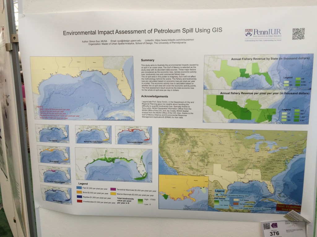
Presenters showcased everything from a first-principals approach from Simon Suo at Penn who is trying to create a GIS to quickly predict possible impacts from a future spill…

Oil Spill geospatial impacts ESRI 2015

…to simple maps pulling together geospatial data such as this visualization of tracking impacts from fracking chemicals upon water tables…

Penn Fracking Map ESRI 2015

…and documentation of expenditures from the Deepwater Horizon spill for post-spill academic studies and ecological restoration projects such as the Deepwater Horizon Project Tracker by the Trust for Public Lands.

DWH Funding Tracker Screenshot

Demo: Standard Post With A Featured Image

Sometimes you’ll want to add featured images to your post. Here’s what a post would look like with a featured image. Lorem ipsum dolor sit amet, consectetur adipiscing elit. Pellentesque pretium, nisi ut volutpat mollis, leo risus interdum arcu, eget facilisis quam felis id mauris. Ut convallis, lacus nec ornare volutpat, velit turpis scelerisque purus, quis mollis velit purus ac massa. Fusce quis urna metus. Donec et lacus et sem lacinia cursus. Lorem ipsum dolor sit amet, consectetur adipiscing elit. Pellentesque pretium, nisi ut volutpat mollis, leo risus interdum arcu, eget facilisis quam felis id mauris. Ut convallis, lacus nec ornare volutpat, velit turpis scelerisque purus, quis mollis velit purus ac massa. Fusce quis urna metus. Donec et lacus et sem lacinia cursus.

Lorem ipsum dolor sit amet, consectetur adipiscing elit. Pellentesque pretium, nisi ut volutpat mollis, leo risus interdum arcu, eget facilisis quam felis id mauris. Ut convallis, lacus nec ornare volutpat, velit turpis scelerisque purus, quis mollis velit purus ac massa. Fusce quis urna metus. Donec et lacus et sem lacinia cursus.

Lorem ipsum dolor sit amet, consectetur adipiscing elit. Pellentesque pretium, nisi ut volutpat mollis, leo risus interdum arcu, eget facilisis quam felis id mauris. Ut convallis, lacus nec ornare volutpat, velit turpis scelerisque purus, quis mollis velit purus ac massa. Fusce quis urna metus. Donec et lacus et sem lacinia cursus. Lorem ipsum dolor sit amet, consectetur adipiscing elit. Pellentesque pretium, nisi ut volutpat mollis, leo risus interdum arcu, eget facilisis quam felis id mauris. Ut convallis, lacus nec ornare volutpat, velit turpis scelerisque purus, quis mollis velit purus ac massa. Fusce quis urna metus. Donec et lacus et sem lacinia cursus. Lorem ipsum dolor sit amet, consectetur adipiscing elit. Pellentesque pretium, nisi ut volutpat mollis, leo risus interdum arcu, eget facilisis quam felis id mauris. Ut convallis, lacus nec ornare volutpat, velit turpis scelerisque purus, quis mollis velit purus ac massa. Fusce quis urna metus. Donec et lacus et sem lacinia cursus.

Demo: Image Post

This is a great way to showcase cool individual images in a quick and easy way. While writing your post: select the image format, add your featured image, then click Publish!

Alternative Choices

I still have not heard back from Torrey Pines State Natural Reserve about my permits. I am currently trying to figure out alternative methods to conduct this experiment, if I do not recieve a collecting permit for that particular site. I am looking forward to returning to the lovely Santa Rosa Island in a week.

Due to the low light pollution, SRI has the most beautiful starry night.

Due to the low light pollution, SRI has the most beautiful starry night.


Fire threatening oil infrastructure

Freeway sign for the Pacific Coast Highway near Solimar Beach burns near Ventura on Saturday, Dec. 26, 2015. (image: KABC)

Freeway sign for the Pacific Coast Highway near Solimar Beach burns near Ventura on Saturday, Dec. 26, 2015. (image: KABC)

The current Solimar Beach Fire raging north of the City of Ventura is threatening numerous oil drilling and storage areas adjacent to Pacific Coast Highway along the Rincon coast of northwestern Ventura/southeastern Santa Barbara County.

12-28-15 23:00 Update:

As of 17:00, Ventura County Fire is reporting 100% containment with only about 70 personnel on the ground engaged in mopping up efforts.  Officials revised the burn area to 562 hectares (1,388 acres). At last report, all oil and gas facilities were reported undamaged.  The same goes for homes and buildings: no significant damage.

12-27-15 22:00 Update:

We have seen some awesome sunsets across Ventura County these last two nights.  The particulates in the air over the western reaches of the county are not posing a health threat (they are primarily blowing right offshore), but are treating us to some wonderful colors.
 

Sunset from W Potrero Road above our CSU Channel Islands campus. Boxing Day, 2015.


Fire officials were reporting 75% containment as of 17:30 Sunday night with fire personnel on scene down to 335 people.  Officials also disclosed the oil operation at the ignition site was part of the holdings of California Resources Corporation.

The active front has moved well inland from PCH.  Comparatively little scorching happened in the immediate coastal zone, with flames apparently jumping PCH over less than a linear mile of freeway.  All told I saw burned hillsides over no more than a five mile stretch of PCH as I drove the area earlier today.


Coastal hillsides along the Rincon section of PCH. This gives you a good idea of what the vegetation looked like as of two days ago (pre-burn).


Coastal hills along the Rincon section of PCH midday on December 27, 2015.


12-27-15 9:00 Update:

See the latest from the VC Star.

Ventura County Fire Officials are now reporting 70% containment.  Staffing is a bit down from yesterday at a reported 426 firefighters on scene as of this morning.

The cause of the blaze has now been confirmed to be private power lines that were blown down by high winds.  These were on an oil production company’s property.  There were near active wells, but those wells were apparently not damaged.  Usually these areas are devoid of vegetation.

12-26-15 23:00 Update:

See the latest from the VC Star and LA Times.

All lanes of PCH and all rail service had reopened at of mid afternoon as winds have continued to slacked throughout the day.  The immediate coastal zone and associated oil infrastructure is mostly out of danger at the moment.  Ventura County Fire Department is reporting 60% containment as of this evening thanks to the huge support in both manpower and air support.


The Solimar Beach Fire

A Ventura County Fire Department engine on PCH as flames from the Solimar Beach fire burning along PCH just north of Ventura on December 26, 2015. (Image: Ryan Cullom)

A Ventura County Fire Department engine on PCH as flames range from the Solimar Beach Fire burning just north of Ventura on December 26, 2015 (Image: Ryan Cullom).

The fire viewed from the city of Ventura. Image: Ventura County Fire.

The fire viewed from the city of Ventura (Image: Ventura County Fire).

Solimar Fire from the cockpit of a Ventura County Air Unit Copter 7 making a pass on the morning of December 26, 2105 (image: tweet from Ventura County Air Unit).

Solimar Fire from the cockpit of a Ventura County Air Unit Copter 7 making a pass on the morning of December 26, 2105 (image: tweet from Ventura County Air Unit).

A train passes a burned segment of hillside e along PCH just North of Ventura, Boxing Day, 2015 (Image: Chuck Kirman/Ventura County Star).

A train passes a burned segment of hillside e along PCH just North of Ventura, Boxing Day, 2015 (Image: Chuck Kirman/Ventura County Star).

A fast-spreading, offshore wind-whipped wildfire has burned as estimated 480 ha (1200 acres) of coastline (as of the 11:00am press briefing on December 26, 2015) near Solimar Beach north of Ventura, California.  The fire has prompted mandatory evacuations along the nearby beach enclaves and a complete closures the 101 Freeway (aka Pacific Coast Highway aka PCH) in both directions as of early Saturday morning.  Rail lines which parallel the freeway along this section of our coast are also shut down until further notice.

Ventura County Fire personnel are working the fire with more than 600 fire fighters on scene or en route to the fight the fire.  The flames are being pushed by a strong northwest wind and currently poses a potential threat to oil, gas, power and rail infrastructure.

Ventura County Fire estimating it will take them about three days to get full containment.

Fire incident map as of midmorning on Boxing Day, 2015. Map: Ventura County Fire

Fire incident map as of midmorning on Boxing Day, 2015. Map: Ventura County Fire

While the actual ignition has yet to be determined, the fire appears to have begun around 10:30 p.m.  Christmas night near the 3000 block of West Pacific Coast Highway.  Overnight flames were within 50 m (150 feet) of the sand and various of our long-term sandy beach monitoring sites.

Solamar Beach Fire freeway closures as of Boxing Day, 2015.

Solamar Beach Fire freeway closures as of Boxing Day, 2015.

Oil & Gas Infrastructure in Harms Way

Fire officials claim to be on cautiously worried about oil and gas facilities in the vicinity, citing the fact that oil companies have cleared ample brush around the perimeters of their operations and are now working closely with emergency personnel to avoid any problems.
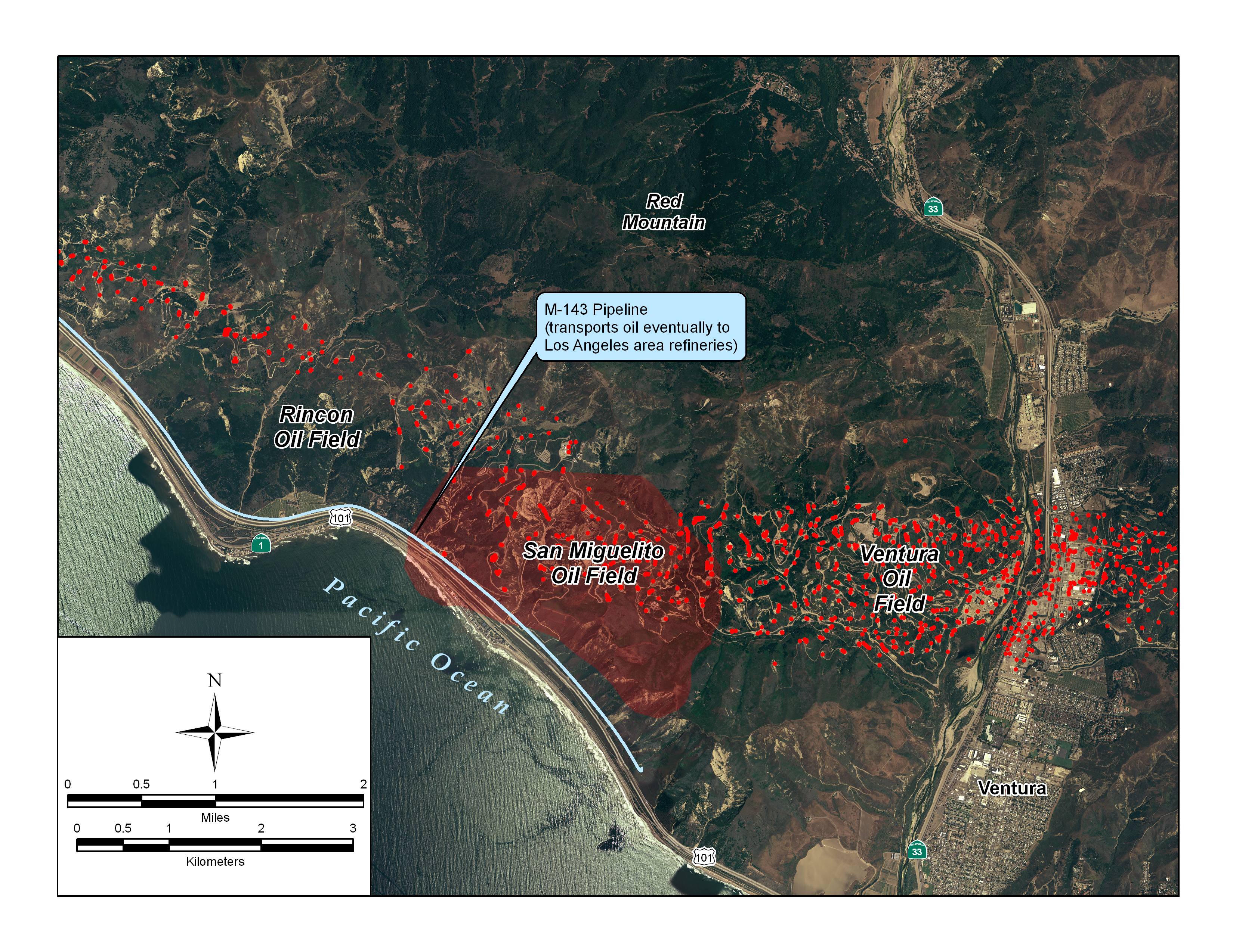
Detail of the San Miguelito oil field partly threatened by Solamar Beach Fire. Red dots are locations of active oil wells as of 2008 (after Wikicommons)

Detail of the San Miguelito oil field partly threatened by Solamar Beach Fire. Red dots are locations of active oil wells as of 2008 (image: Wikicommons).

Altered Freeway Traffic…

Union Pacific Rail, PCH, and the 101 Freeway from State Route 33 to State Route 150 were closed as of early morning on December 26 given both the proximity of the fire to the roadbed and the fact flames were sporadically jumping PCH itself and igniting vegetation on the seaward side of the roadbed.

Given the complete closure of the Rincon, the alternative route for this major north-south corridor was via the 150 and 33 highways.  As someone who regularly drives this twisting, curvy route, I was relieved to see that the California Highway Patrol recommended big rigs NOT take State Route 150.

…will Kill More Animals

Our lab is uniquely positioned to quantify the potential unintentional consequences of this necessary, altered traffic flow.  More on this later, but in brief we have been monitoring wildlife road kill across southern California roads for the past decade and have robust estimates of how many critters are killed on more than 50 roadways in and around Ventura County.

Before this closure we had documented the following kill rates along these three roads (the Rincon section of the 101, the 33, and the 150):

road Segment milage speed limit (mph) mean kills per mile max vehicles per hour mean vehicles per hour
33 (Ojai) 11.2 55 0.20 3,120 1,352
150 (Casitas) 16.5 45 0.20 600 227
101 (Rincon) 12.6 65 0.06 7,772 4,315

As the 33 is one of our most intense concentrations of road kill in the county, I estimate that as we boost the traffic flow along the 33 and 150 highways, we will see perhaps an additional 58 animal kills that we would not have seen had the bulk of the traffic remained on PCH/had we not had this fire.

Demo: Little Red Riding Hood (Embedded Video)

Looking to embed videos from YouTube, Vimeo, or any of the other popular video sites? No problem at all. Simply take the embed video code, add it to the video settings, and you’re done.