Hello world!
Welcome to WordPress. This is your first post. Edit or delete it, then start blogging!
Welcome to WordPress. This is your first post. Edit or delete it, then start blogging!

I am participating in the cMOOC, How to Teach with WordPress. Today, I attended the live kick-off webinar and after my usual argument with Blackboard Collaborate, I had an enjoyable 30 minutes. My interests in enrolling in this course are primarily to gain more expertise with WordPress. My institution, CSU Channel Islands, started CI Keys, an off shoot of Domain of One’s Own (a la @JimGroom and crew) and faculty and staff have been digging deep into the potential of WordPress.
I’ve taught in an LMS since I started teaching online ten years ago. However, throughout most of those years, I designed my learning environment to incorporate tools from the web (VoiceThread, Ning, Tackk to name a few). These tools were used to enhance the collaborative nature of the environment, as well as foster a my instructor presence and social presence. The idea of teaching in an “open” environment and embracing what we’re calling “open pedagogy” is exciting to me. Yet, I am fully aware that this is a huge barrier to the faculty who teach at institutions that have not established a position about teaching and learning in the open web. On the other hand, there are faculty doing incredible work in the open web and I want to learn more about this niche.
Today’s webinar touched upon some unexpected topics, which I appreciated. The facilitators shared a table that provided a lens for examining different quadrants of “open pedagogy.” A quote by David Wiley was used to frame this concept: “At it’s core, the question of open pedagogy is ‘what can I do in the context of open that I couldn’t do before?’” I like this question, as it provides a starting point for each individual educator to reflect on where they are and where they could go in an open learning environment.
This is important to me, as I have transitioned from an instructor role into a faculty development role. As I approach a new pedagogy, I view it through the lens of different instructors and students (with varying attitudes and perceptions about technology).
For me, my goals are to understand how to use WordPress in a way that is clear and simple enough for students to learn effectively in classes that do not denote a technology requirement (lower division general education classes, for example). Honestly, WordPress has not been as easy for me to learn to use as I had hoped it would. I’m still learning through trial and error, not to mention endless Google Searches. Yet, I am committed to the need to ensure students learn in an environment that is aligned with the same challenges and opportunities they will encounter after graduation. And no LMS can provide that.
So, I’m looking forward to the weeks ahead, improving my WordPress skills, and plunging into the depths of the messy, murky topic of open pedagogy with some fabulous connected educators.

As summer comes to an end, I’m preparing to brand and develop a webpage/blog.
Welcome to WordPress. This is your first post. Edit or delete it, then start blogging!

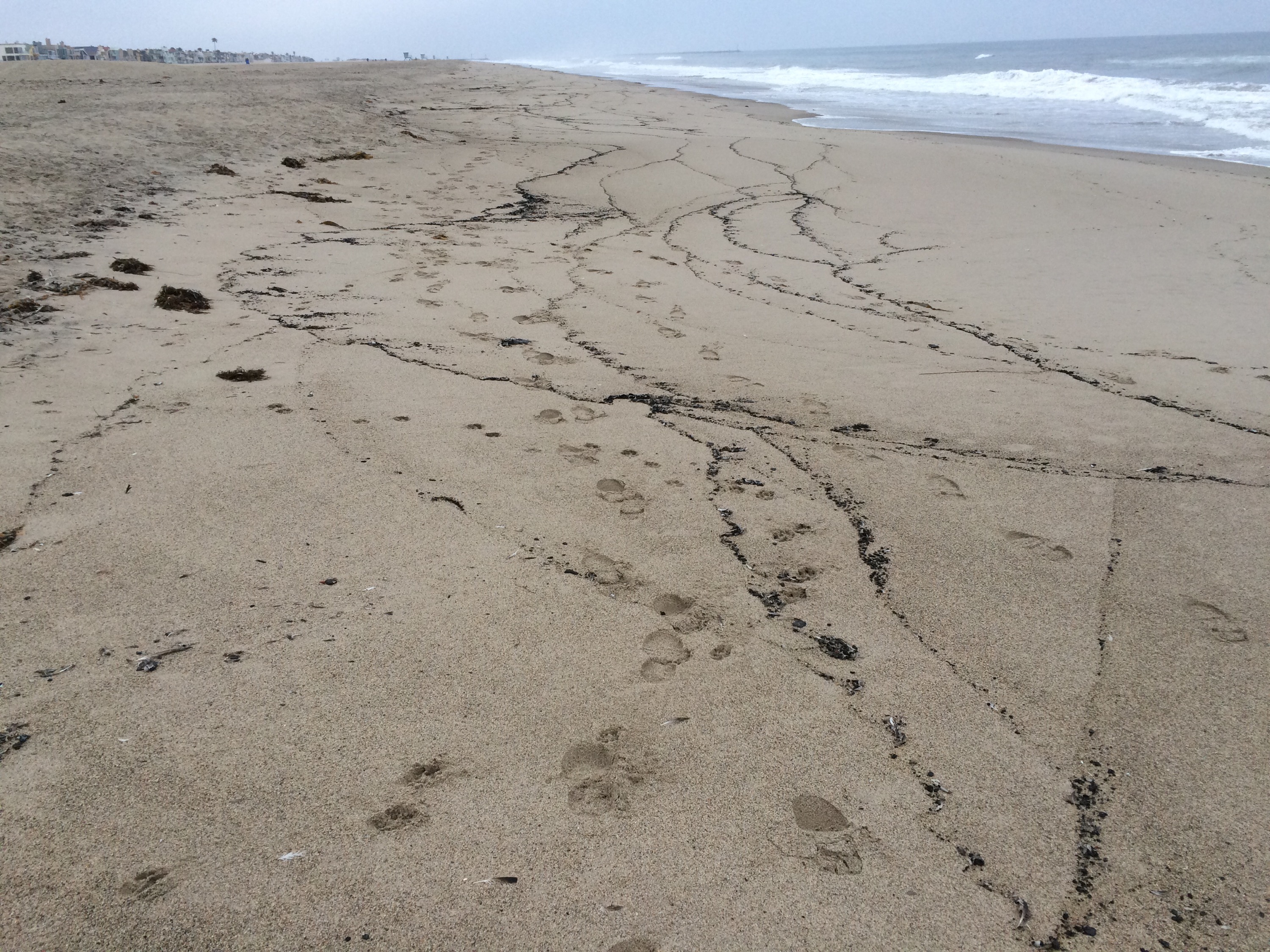
Tar ball strand line at the wrack line at Ventura State Beach on May 30, 2015.
We have been getting lots of inquires about this crazy tarballing going on across Santa Barbara, Ventura, and Los Angeles Counties. I thought I would give a quick overview of tar balls in our part of the world; the Southern California Bight.

Just-deposited fresh tar ball at Zuma Beach, Los Angeles County. May 30, 2015.

Natural sandy beach oil seep in Santa Barbara. Image: USGS.
Oil has been deep underground for millions of years, more or less undisturbed. Indeed our sucking out all that stored carbon and then effectively spitting that carbon up into our atmosphere is the central driver of climate change and (what I like to call) global weirding (aka global warming). Petroleum is mostly the product of dead plankton and plants, not so much dead dinosaurs as the popular conception normally goes (but I digress…). Oil and gas essentially build up in porous subsurface rock formations capped by impervious rock. This creates an oil and/or gas pocket which humans learned to tap beginning in the mid-to-late 1800s. But long before we ever learned to stick fancy metal straws down into these hydrocarbon rock pools, that “black gold” has been naturally leaking up to the surface since these formations first formed. These leaks or seeps happen when the overlying rock formations develop fractures or cracks in them, letting the oil or gas flow up to the surface quickly or slowly. Seeps have played important roles in human society for thousands of years.
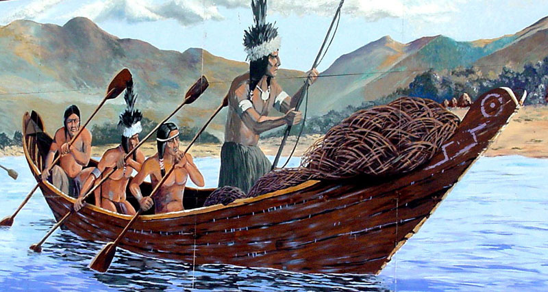
Chumash tomol. Image: www.missionscalifornia.com
Our local seeps in Santa Barbara and Ventura Counties featured most prominently in Chumash culture and technology. We have evidence of humans using seep tar at least as early as 5,000 B.C.E. with Chumash actively trading their tar with other, distant tribes for at least the past 1,000 years. Perhaps the most iconic use of the tar seeping from the ground across our region were the Chumash ocean-going tomols. These Chumash canoes were unusual and not constructed as a watertight vessel per se. Instead, these vessels were constructed of planks. Once assembled the final waterproofing included scooping up a bunch of tar from a local seep and then plastering/in-filling of any gaps between planks to create a superior seal and watertight boat. Spanish explorer Juan Rodriguez Cabrillo was particularly impressed with this technology and noted these unique canoes in the logs of his 1542 exploration of the Ventura and Santa Barbara coasts. Cabrillo even used Chumash tar to caulk and repair his own vessels. Our current Chumash people are active in preserving their traditions and culture and continue to construct traditional tomols to traverse the 17+ mile gap from the mainland to our channel islands.

Chumash arrive at Santa Cruz Island in a modern Tomol. Photo: National Park Service.

Summerland oil piers near Santa Barbara, circa 1901-1903. Image: Title Insurance and Trust / C.C. Pierce Photography Collection, USC Libraries.
Our first definitive confirmation of natural seeps depositing tar balls on our local beaches dates to 1772 and the journal of Padre Pedro Font (a member of Juan Bautista De Anza’s colonizing expedition). Font noted tar balls on the beach and slow motion seeps pouring asphaltum (which is just what it sounds like) down cliffs and bluffs into the ocean. With the European settlement of California, more modern extraction and uses of oil began to take hold. Oil extraction was initially concentrated at and near surface seeps where the emerging tar was scooped up directly, soon to be quarried as we traditionally mine gravel or other rocks. In those early days of the mid 1800’s, harvested tar was used principally to pave roads, fuel oil lamps, and as a lubricant for heavy machinery. From 1870-1890 more and more oil and gas wells sprang up as settlers encountered petroleum where they had hoped to find water in their boreholes. All heck broke loose following the first-in-the-world offshore oil production derricks (via long, wooden piers jutting out into the surf) off of Summerland in 1896. And the rest, as we say, is history.

Summerland offshore wells near the end of the play of this nearshore reservoir. Image: Museum of Ventura County.
Oil and gas seeps presents themselves both on the terrestrial surface and the ocean bottom. Flow can be highly variable, changing with seasons, tectonic pressures, temperatures, and a myriad of factors we poorly understand. This can complicate the source tracking when we are interested in figuring out if a tarring event or individual slick originated from a seep or a spill.

Remotely Operated Vehicle video still showsing a crab near the top of extruding tar on a tar mound in the Santa Barbara Channel. Lack of colonizing sessile organisms suggests that this mound is quite young. Image source: Lorenson, et al. 2009.

An approximately 3 m-long tarwhip extruding from an extensive tar mound offshore of Pt. Conception at a depth of 41 m. During this dive, many such tar whips were observed, all extruding from tar mounds. Some such whips broke off and floated to the surface while others did not retain buoyancy and fell to the ocean floor. Image source: Lorenson, et al. 2009.
Released oil and gas experiences a wide array of possible fates, including migration to the atmosphere, hanging out in the water column or surface layer, deposition upon the benthos, and degradation/transformation by the microbial community.

The fate of oil from a natural seep in the Santa Barbara Channel. Image source: Woods Hole Oceanographic Institution (2009).
We have a wide range of naturally oil seeps across Ventura and Santa Barbara Counties. Examples of known seeps and some of the resulting slicks are below. You can also check out this killer site from the USGS documenting known seeps across California.

Southern California Bight showing possible oil slicks and seeps. Colors coded by confidence level where green>red>pink. Possible oil pollution slicks are seen in yellow tones. Image source: Fugro NPA Limited satellite mapping services.
One of the particular challenges with tracking surface slicks from seeps or spills revolves around the complicated surface currents and eddies we experience in the Santa Barbara Channel. This is due to both the geography of the Santa Barbara Channel, Point Conception, and the Transverse Range. As a result, we can get movement in virtually any direction, although we generally get migration eastward and southward during the spring and summer. To date, the surface slick from the Refugio Oil Spill has primarily migrated offshore with two main lobes, one going more or less straight offshore and a second migrating eastward down the coast. As of this writing, we have no direct evidence that oil from the Refugio Spill migrated any great distance. However the tar balling of beaches in Santa Monica Bay and the Ventura coastlines might have been translocated oil from that Refugio source. Below is an overview of the general surface flow patterns in the Santa Barbara Channel.

Dominant patterns of surface currents in the Santa Barbara Channel.

Example tar ball chromatograms from the Santa Barbara Channel. Chromatograms of selected tarball samples. Total ion chromatogram (TIC) of aliphatic (A) and aromatic (B) fractions; Selected ion monitoring (SIM) chromatograms of m/z 191, Hopanes (C), and m/z 217, Steranes (D,E,F). Compounds identified in Table 2-1. Legend : MAS, monoaromatic steranes; Steranes, C26 to C29 regular steranes; Hopanes, C27 to C35 regular hopanes; BN, 28,30-bisonorhopane; UCM, Unresolved Complex Mixture. 23T, C23-tricyclic terpane; C24, C25, C27, C38, tricyclic terpanes; T, triplet, defined in text; Ts and Tm, defined in text; BN, bisnorhopane; ab29, ab30, ab31 through 35 (S & R epimers), ab-hopanes with carbon numbers; O, Oleanane; and G, Gammacerane. (D, E, F) Mass chromatograms (m/z 217) of C27, C28, and C29 steranes and C27 diasteranes in a selected coastal tar residues representing Families 22, 212, and 32. Legend: S,R = epimers of aaa27, 28, 29 and bb27, 28, 29 steranes. Image after Lorenson, et al. 2009.
The only definitive way to tell if the oil presenting itself on a given beach is from a seep or from an anthropogenic release (i.e. the Refugio Spill) is via chemical forensics. We do this by “fingerprinting” the oil. This essentially means grabbing the oil, getting it nice and liquid-y and then running those sample through a machine that can characterize the various chemical compounds. This analyzer can distinguish biomarkers or the “fingerprint” of amazingly complex organic compounds and the isotopes of individual carbon atoms that comprise a given oil sample. Frequent targets that will help with distinguishing the source formation include unusually “heavy” d13C, high C35 ab-hopane 22S and 22R epimers compared to C34, and prominent sulfur-containing PAHs, such as dibenzothiophenes. The last step is to run a sample of the candidate source oil (say from the Refugio Pipeline crude) and see if the two compounds’ peaks overlap.
Although the chemical components are common to essentially all tar balls, their relative proportions will vary with the oil sources. The chemical “fingerprinting” should use both the ratios of these array of constituents, plus additional markers from both aliphatic and aromatic hydrocarbons (see Hostettler et al., 2004).
The chemical composition of the tarballs also sheds light on their geochemical history. Despite tons of offshore, shallow seeps, and the constant impingement of tar onto the shoreline, little is known about the mechanics of the hydrocarbon formation in the shallow seeps, specific sources of tarballs, or their transport from the marine environment onto the shore.
While not perfect, this “fingerprinting” has been used to track not only the source of oil, but look at how that material has moved across our nearshore seascape. As we know that tar balls from offshore seeps can be transported significant distances from their sources by ocean currents, oceanographers have used tar ball source tracking to infer circulation patterns and nearshore currents. This amounts to researchers using oil as effectively a drifter.
There are many critters particularly at risk with this oil spill. While our historic worry/focus has been on our rocky intertidal communities and on warm fuzzies (such as these cute marine mammals and endangered sand-nesting birds), other critters are at risk too. In particular the animals dwelling in the swash zone of our sandy beaches. What I am most worried about here are the sand crabs (Emerita analoga) that are the food for a huge number of beach-dwelling birds and animals and our California grunion (Leuresthes tenuis).

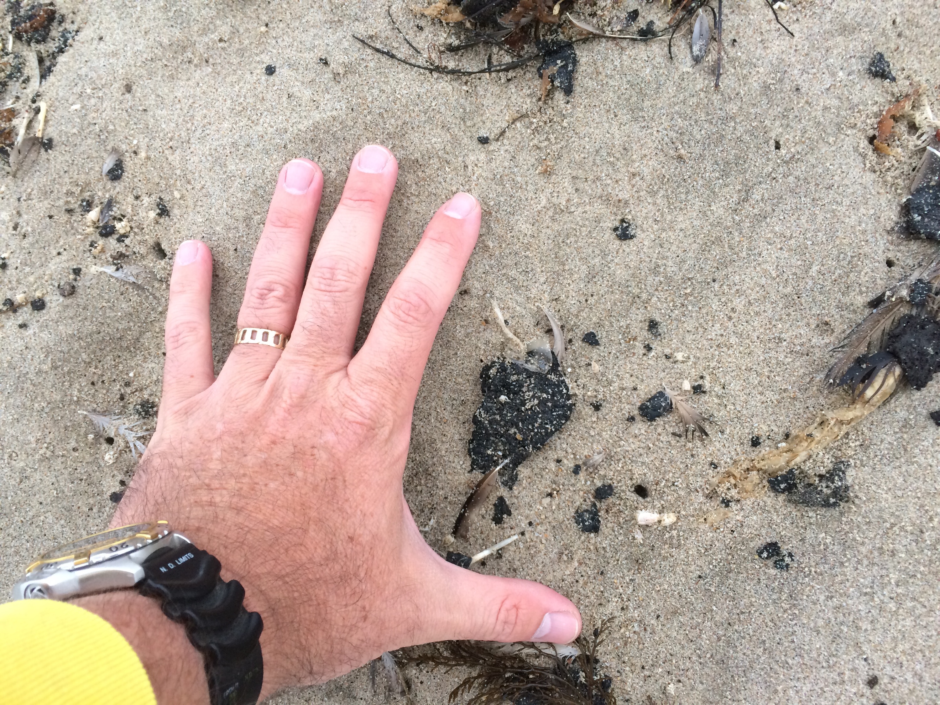
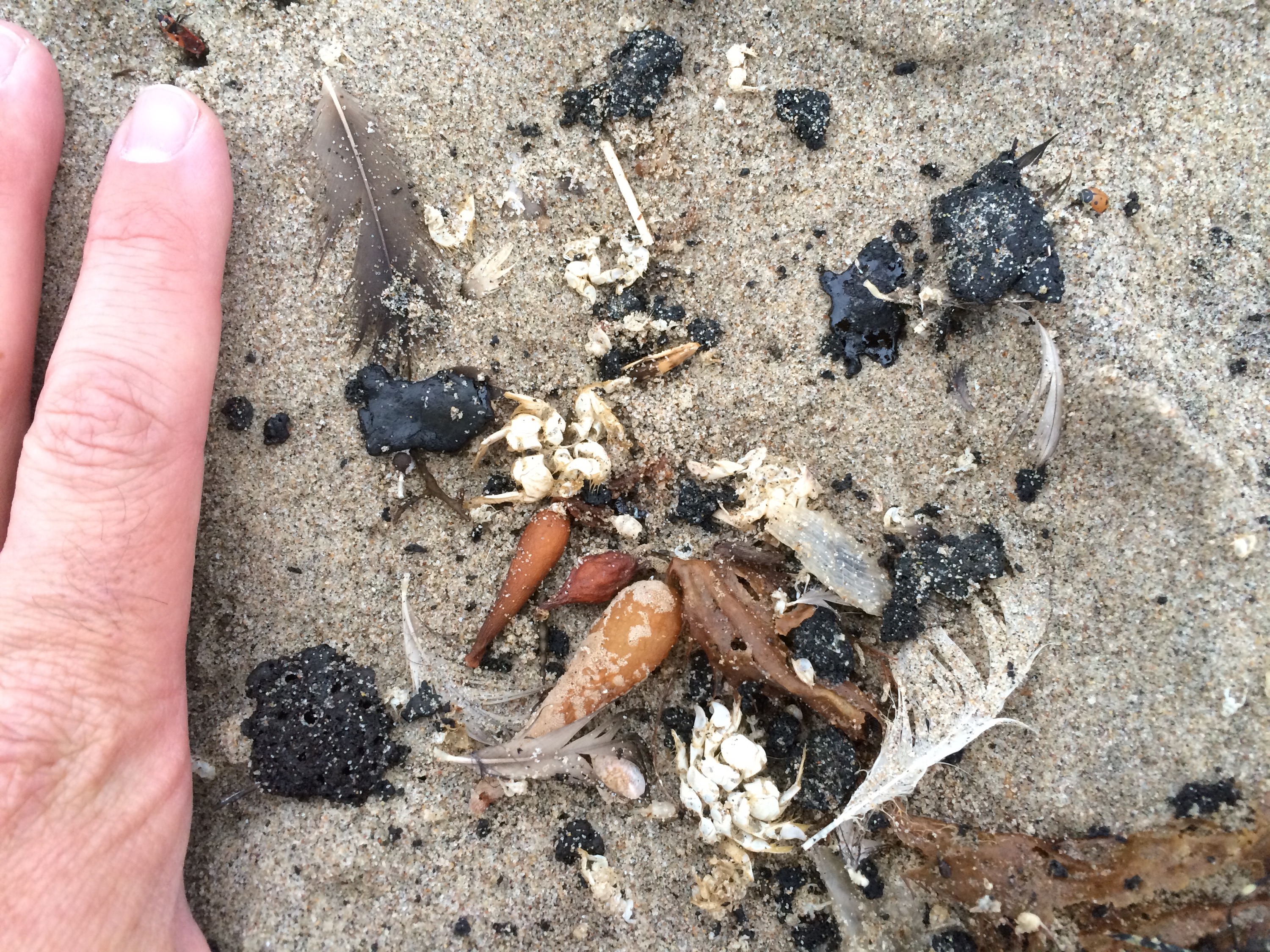
Large sand crab carapace in the fresh tar line at Oxnard Shores, Ventura County on May 30, 2015.
Sand crabs make their living migrating up and down the beach with the tides (they live in the sand, sticking up their food-collectors to harvest their planktonic food and the waves wash over their sand-home), keeping themselves right at the swash zone where the waves hit. That’s right where all these tarballs are washing up. As of yesterday, we have been finding dead sand crabs in amongst the freshest wave of tarballs arriving on our beaches in Ventura County.
It is too early to say if we are seeing a significant mortality event within our sand crab population, but it is concerning that we are seeing so many dead guys (not mere cast-off exoskeletons or dead juveniles).
Given the fact that sand crab numbers have been low this year prior to the onset of the pipeline break/oil spill, any tar-induced mortality might prove harmful to the population and sandy beach community overall. The bright side of this is that these are resilient and highly variable populations and we may see no effect.

A grunion run near Cabrillo Aquarium in Los Angeles, CA. Image: CBS News
When it comes to California grunion, the worry is that we are in peak spawning time. These amazing fish swim up to the beach at night to lay their eggs before rolling and flopping back into the water. Their eggs chill out in the sand until they are ready to hatch with the next series of high tides.
Both sand crabs and grunion are vulnerable to both the toxic oil and the clean-up process alike. Simply skimming the oil off the very uppermost surface of the sand is not an issue, but digging into the sand translates into possibly digging into these guys and killing them. Clean-up crews need to be as careful as is reasonable.
See this e-mail from our queen grunion champion Dr. Karen Martin:
Whatever their source may be, these tar balls have the potential to impact beach and nearshore animals and plants, including the California Grunion…
[the impacted areas] are known spawning locations for the California Grunion, an endemic, iconic marine species. Any eggs still on shore this weekend are ready to hatch and likely to emerge during the high tides at night over the past and next few days. However, the tar balls in the intertidal zone are very nearly in the location of the band of buried grunion eggs.
With all appropriate human safety precautions, when cleaning the beaches, it is important to leave the sand as undisturbed as possible if the contamination is only at the surface. The best practice seems to be gentle manual removal of the surface petroleum, with flat shovels or hand rakes. Some people are using cat-litter scoops.
We are still in the midst of the peak spawning season for the California Grunion. The full moon Tuesday June 2 will be followed by nights with potential runs on Tuesday, Wednesday, Thursday, and Friday. Grunion usually spawn multiple times over their lifespans. It is rare that they die during spawning runs. If you do see an unusual mortality event, please let me know as soon as possible…
…Please recall that after this week the nests of eggs will be present on shore for the following two weeks. Keeping vehicles and other forms of disturbance above the high tide line of Tuesday’s highest tide is the best way to protect them.
Thanks for your care of our beaches and natural resources during this difficult time.
We are seeing tar ball strand lines as the high tide retreats this morning. Intermixed in these tar lines are dead sand crabs/carapaces.
Tar balls not evident near Hueneme Pier but many consistent, wispy tar lines starting at Oxnard Shores / west of Channel Islands Harbor.
More details as we observe during today’s monitoring.

Oil clean-up crews at Haskells Beach mid-morning May 29. 2015
Holy cow! It has been a crazy day. One of our teams sampling Haskell’s Beach (near the Bacara Resort) north Coal Oil Point was basically given the boot. Various clean-up teams are now sweeping the beaches from El Capitan to Goleta and the Incident Command has now shut down public access to all of those beaches. This is a huge expansion of the closure area and seems to confirm our concerns beginning mid last week that much of the oil arriving to beaches down to Coal Oil Point was indeed pipeline crude and not merely regular, background tar seep deposition.
While one of our teams checking Carpinteria found nothing particularly abnormal about the tar balls there at 4pm today, we now have reports of dime-to-baseball sized tar balls washing up on several of our monitoring beaches here in our own backyards in Ventura County. It is unclear if this is related to the spill, but we RARELY IF EVER get this kind of tarring on these beaches. This is certainly an unusual event and seems very suspicious. We need to have the fingerprinting of the oil to confirm but at a minimum, this is very weird.
Here is a quick video by Paul Spaur summarizing the goings on before the beach was closed:
We will post more when we know more.

More boom, less people. Newly boomed off sandy beach edge at Haskell’s Beach May 29, 2015
From the LA Times about 15 minutes ago:
The cleanup response to the oil spill that fouled miles of beaches along the Santa Barbara County coast will now extend to Ventura County, where tar balls have been spotted on beaches, officials said Friday.
The pipeline’s owners said it will dispatch cleanup contractors to Hollywood, McGrath and San Buenaventura beaches in Ventura County, though federal authorities have not confirmed whether the oil there is from the spill.
“Until we know more, we will act as if it is related to our incident,” said Rick McMichael, senior director of operations at Plains All American Pipeline, which operates the pipeline.
read the full story on the LA Times website.

Workers continue to clean the shoreline at Refugio State Beach in Santa Barbara County after a crude oil pipeline ruptured on May 19, spilling thousands of gallons into the ocean. Photo: Genaro Molina / Los Angeles Times
From the Ventura County Star Website:
By Friday afternoon, crews were cleaning up tar balls at San Buenaventura and McGrath.
Two beaches north of Santa Barbara, also in the Channel Coast district, were closed last week after an estimated 21,000 gallons of oil spilled into the ocean off Refugio State Beach. There’s no indication the tar balls on the Ventura beaches were related to that spill nearly 50 miles away. But officials don’t know where they came from at this point.
“An initial analysis came back inconclusive as to what the source is,” said Kevin McGowan, manager of the Ventura County Sheriff’s Office of Emergency Services. The Emergency Operations Center has been activated to support the investigation and cleanup efforts.
McGowan was with a team early Friday checking out the sites where the oil was reported.
“They range from the size of a dime or a quarter to a dinner plate,” he said. “Stretches (of the tar balls) span anywhere from 10 to 50 feet long.”
No closures were reported Friday afternoon.
“There doesn’t appear to be a significant threat to public health or wildlife in Ventura County at this point,” said Chris Stephens, the county’s resource management director. “Our goal at this point is to find the oil, remove it and mitigate any environmental impact it may have caused.”
Those responding to Ventura-area beaches Friday would assess whether the tar balls need to be cleaned up. County officials said cleanup teams had been deployed to the area.
A fly-over of the ocean done as part of the cleanup efforts of the Santa Barbara County oil spill was expected to include the Ventura County area Friday. McGowan said he had not yet heard the results from Unified Command, but so far, there were no reports of oil in the water off the Ventura coast.
Earlier this week, a 7-mile stretch of coastline along Santa Monica Bay was closed after globs of oily goo washed ashore. Officials said the area might reopen Friday after a two-day cleanup effort.
Update: 6:30pm
My students are reporting lots and lots of small to medium-sized tar balls washing up on western Ventura County Beaches. These tar balls are dense enough to begin forming a line of tar at the strand / high tide line. We are also seeing dead sand crabs (one of the foci of our sandy beach work and a keystone species for sandy beach ecology) intermixed at this tar sand line at McGrath State Beach and Emma Wood State Beach.

McGrath tar ball stand line on May 29, 2015.

Dead sand crabs (Emerita analoga) at McGrath State Beach tar ball stand line which formed on May 29, 2015.

McGrath tar ball stand line on May 29, 2015.

>10cm wide tar ball at McGrath State Beach tar ball stand line on May 29, 2015.

Tar ball strand line at McGrath State Beach in Ventura, CA on May 29, 2015.
Welcome to WordPress. This is your first post. Edit or delete it, then start blogging!