Posts

An X Prize for Going Deep

The Shell Ocean Discovery XPRIZE seeks to usher in a new era of deep exploration of the oceans.  This will both help with/foster both basic and applied research.  Not the least of which will be to boost our understanding of baseline conditions before subsequent impacts from deep sea mining of oil/gas extraction.

Formal Announcment

Here is the full text of the announcement from yesterday’s announcement at the American Geophysical Union’s Fall meeting in San Francisco:

At a keynote address today during the American Geophysical Union Fall Meeting in San Francisco, Dr. Peter H. Diamandis, chairman and CEO of XPRIZE, announced the launch of the $7M Shell Ocean Discovery XPRIZE, a three-year global competition challenging teams to advance ocean technologies for rapid and unmanned ocean exploration. As part of the total $7M prize purse, the National Oceanic and Atmospheric Administration (NOAA) is offering a $1M bonus prize to teams that demonstrate their technology can “sniff out” a specified object in the ocean through biological and chemical signals. David Schewitz, Shell vice president of geophysics for the Americas, and Richard Spinrad, chief scientist at NOAA, joined Diamandis on stage to launch the new competition.

“Our oceans cover two-thirds of our planet’s surface and are a crucial global source of food, energy, economic security, and even the air we breathe, yet 95 percent of the deep sea remains a mystery to us,” Diamandis said. “In fact, we have better maps of the surface of Mars than we do of our own seafloor. The Shell Ocean Discovery XPRIZE will address a critical ocean challenge by accelerating innovation to further explore one of our greatest unexplored frontiers.”

The three-year competition includes nine months for team registration, 12 months for initial solution development and 18 months to complete two rounds of testing and judging by an expert panel. In each round, teams will complete a series of tasks, including making a bathymetric map (a map of the sea floor), producing high-resolution images of a specific object, and identifying archeological, biological or geological features. Teams also must show resiliency and durability by proving they can operate their technologies, deployed from the shore or air, at a depth of up to 4,000 meters.

“Spurring innovation and creating radical breakthroughs in ocean discovery are what excite us about collaborating with XPRIZE,” Schewitz said. “Shell recognizes the need to leverage the full power of innovation: the capacity for doing things differently and better than before.”

A $4M Grand Prize and $1M Second Place Prize will be awarded to the two teams that receive the top scores for demonstrating the highest resolution seafloor mapping, after meeting all minimum requirements for speed, autonomy and depth. Up to 10 teams that proceed to Round 2 will split a $1M milestone prize purse. And the $1M NOAA bonus prize will be awarded to the team that can trace a chemical or biological signal to its source.

“The goal of the $1M NOAA bonus prize is to identify technology that can aid in detecting sources of pollution, enable rapid response to leaks and spills, identify hydrothermal vents and methane seeps, as well as track marine life for scientific research and conservation efforts,” said Spinrad.

The Shell Ocean Discovery XPRIZE is part of the 10-year XPRIZE Ocean Initiative – a commitment made to launch five multi-million dollar prizes by 2020 to address critical ocean challenges and make the oceans healthy, valued and understood. XPRIZE awarded the Wendy Schmidt Oil Cleanup XCHALLENGE in 2011 and the Wendy Schmidt Ocean Health XPRIZE in July 2015.

For more information, and to register your intent to compete, visit oceandiscovery.xprize.org.

About the XPRIZE

Founded in 1995, XPRIZE offers so-called Grand Challenges by creating and managing large-scale, high-profile, incentivized prizes in five areas (think lots of testosterone in the guise of learning something…very silicon valley): Learning; Exploration; Energy & Environment; Global Development; and Life Sciences.

Active prizes include the $30M Google Lunar XPRIZE, the $20M NRG Cosia Carbon XPRIZE, the $15M Global Learning XPRIZE, the $10M Qualcomm Tricorder XPRIZE, and the $7M Adult Literacy XPRIZE.

The Loot


The $7 million prize purse will be awarded as follows:

  • Grand Prize: $4 million will be awarded to the first place team that receives the top score that meets or exceeds all minimum requirements.
  • Second Place Prize: $1 million will be awarded to the second place team that receives the second highest score that meets or exceeds all minimum requirements.
  • Milestone Prize: $1 million will be split among the top (up to) 10 teams from round 1.
  • NOAA Bonus Prize: $1 million will be awarded in round 1 to the team that successfully identifies the source of an established biological or chemical signal. This will roll over to round 2 if there are no winners in round 1. Participation in the bonus prize will be voluntary for registered teams.


Competition Summary


Teams will compete in two rounds for a total prize of $7 million:
Round 1 testing will be conducted at 2,000 meters depth.
Round 2 testing will be conducted at 4,000 meters depth.

For both rounds, Teams must launch from shore or air and, with restricted human intervention, their entries will have limited number of hours to explore the competition area to produce:

  1. a high resolution bathymetric map
  2. images of the specified object
  3. identify archeological, biological, or geological features
  4. track a chemical or biological signal to its source (bonus prize)

Refugio Spill Talk at WSN

Last weekend our sandy beach troupe made the long (6.5 hour) drive up to Sacramento for the 96th annual meeting of the Western Society of Naturalists.  This is a core meeting for our research group and one of the few meetings we attend every year, rain or shine.  This year’s meeting saw several of our students and professors presenting their recent work related to our continuing efforts to monitor and explore the sandy beaches of southern California and the greater Pacific.

I presented our research group’s first formal academic talk about the ecological and socioeconomic impacts from the May 2015 Refugio Oil Spill in northern Santa Barbara County.  The abstract of our talk and my actual presentation are below:


Ecological and Sociological Impacts of the May 2015 Refugio Oil Spill

Anderson, S.S.1*, Wormald Steele, C.L,1, O’Hirok, L.S.1, Rodriguez, D.A.1, Spaur, P.A.1, Schmitt, T.J.1, Tillman, C.1,2, Pratt, R.T. 1, Newell, A.L.1, Anderson, S.S.1 and Anderson, G.D.3

1 – California State University Channel Islands, 2 – Moorpark Community College, 3 – Oaks Christian Middle School

The Plains All American pipeline rupture on May 19, 2015 spilled an estimated 79,000 l (21,000 gal, 500 bbls) of unrefined crude oil onto Refugio State Beach (Santa Barbara County, California) and into the Pacific Ocean. Heavy littoral oiling affected Refugio and El Capitan State Beaches immediately. Highly variable tarring episodes impacted beaches as far as 170 km from the break over the ensuing weeks, creating a unique arena in which to test tarring impacts. Sandy beach ecosystems dominate the shorelines of these regions and so bore the brunt of the impacts from this spill. Infaunal diversity dropped and heretofore unobserved conspicuous dead Emerita analoga (sand crabs) were common in the swash zone across several beaches although an independent decline in sandy beach infaunal diversity/abundance across the region over the past year made impact detection problematic. Laboratory experiments confirmed the toxicity of deposited tar to developing Emertia embryos, juveniles, and adults. The spill had immediate but mostly ephemeral effects on people: reducing summer spending at the most heavily tarred beaches by an order of magnitude, halving the number of people who felt Santa Barbara-area seafood was safe to eat, and bolstering support for offshore drilling bans.


I am at a loss for why my voice was so fried during my above talk.  It may have something to do with the student auction I co-hosted (along with the good Dr. Mark Steele from CSU Northridge) the night before, but then again it was generally a regular Saturday night…

Drs. Sean Anderson (disguised as Perry the Platypus), Mark Carr (disguised as Marilyn Monroe), and Mike Dawson (disguised as a UC Merced Professor) engage in witty banter in the wake of the Student Auction. Western Society of Naturalists Meeting, Sacramento, CA on November 7, 2015.

Drs. Sean Anderson (disguised as Perry the Platypus), Mark Carr (disguised as Marilyn Monroe), and Mike Dawson (disguised as a UC Merced Professor) engage in witty banter in the wake of the Student Auction. Western Society of Naturalists Meeting, Sacramento, CA on November 7, 2015.

Clearly, my talk enthralled all who attended…

Vanessa, Dorothy & Tevin are tired WSN 2015

Vanessa, Dorothy, and Tevin are enlivened by my incredibly interesting and engaging talk on the Refugio Oil Spill.


Pipeline Repairs Will Take A Loooong Time

News is just breaking that the repair of the embattled trunk line delivering crude oil from Refugio’s onshore distribution facility to refineries in Kern County that ruptured last May and caused the Refugio Oil Spill may take a long, long time to repair.

While I have found such estimates to almost assuredly be overblown, the sheer order of magnitude (years) is quite noteworthy here and speaks to aging infrastructure that may not have been as well maintained as we would all like to think.  The infrastructure crisis in the U.S. in not just a government issue: the private sector can be similarly cheap.  We last, most dramatically, saw this with BP’s “run to failure” policy in Alaska and across various other global oil production units.

An aerial photo of the section of pipeline that ruptured on May 19, 2015 and ultimately sent crude oil into the ocean at Refugio State Beach. Federal investigators found  extensive corrosion in that section of pipe. Image: John Wiley.

An aerial photo of the section of pipeline that ruptured on May 19, 2015 and ultimately sent crude oil into the ocean at Refugio State Beach. Federal investigators found extensive corrosion in that section of pipe. Image: John Wiley.

From the Pacific Coast Business Times:

excerpted from Alex Kacik’s November 5th 2015 piece Refugio oil spill pipeline might take five years to get back online


The pipeline that was responsible for the Refugio oil spill in May could take up to five years to get back online and the best-case scenario is 18 to 24 months, according to California Economic Forecast Director Mark Schniepp.

He spoke to a room full of the biggest oil players in Santa Barbara County, public officials and members of the Chumash on Nov. 5 about Santa Maria and the region’s economic future, which are inextricably tied to the oil and gas industry.

If Houston-based Plains All American Pipeline’s Line 901 remains dormant over the next three years, Santa Barbara County could lose out on an estimated $74 million, Schniepp told about 100 people at the Economic Action Summit at the Radisson in Santa Maria.

The county would potentially miss out on about $5 million in federal royalties, $37 million In property taxes, 155 jobs and $32 million in worker income.

“This could probably be expedited and, given the economic impacts I’m about to show you, it ought to be expedited,” Schniepp said about making Line 901 operational. “There are a lot of claimants losing a lot of dollars and will lose them going forward.”

…Exxon is the region’s biggest oil operator, producing nearly 30,000 barrels per day that generated nearly $1.2 billion in revenue last year. Exxon was on pace to make an estimated $636 million in Santa Barbara County in 2015, Schniepp said, but it has only generated an estimated $216.6 million because production was shut down after the May oil spill. About 65 jobs may be transferred to other Exxon facilities, he said

Santa Barbara County recently rejected Exxon’s emergency application to truck oil to refineries because the company did not prove that an emergency exists, the county said.

“It seems that we should probably do what we can do to get things up and running in order to enjoy the benefits we had prior to the shut down,” Schniepp said. “People are going to feel it.”

…Since the oil spill, public officials have called for more vigilant pipeline regulation, requiring the use of new technology and improving oil spill response. Gov. Jerry Brown signed three bills that require the California Fire Marshall to review oil pipeline conditions every year, not every five years as mandated by more lax federal regulations; aim to make oil spill response faster and more effective; and force intrastate pipelines to use the best-known technology such as automatic shutoff valves. Line 901 is an interstate pipeline.

Air Quality & Urban Oil Fields

Source: Southern California air board puts new restrictions on urban oil fields – LA Times

We have seen a spate of complaints about air quality near our urban oil fields here in southern California over the past few years.  This appears related to increased use of hydraulic fracturing methods to free up oil and gas and so increase yields from what have become relatively low production, “exhausted” fields.  I am often amazed to see the lengths production companies have gone to in the hope of camouflaging oil derricks and pipes from the casual observer and how frequently locals are unaware of what is going on in their neighborhoods in the context of oil and gas production.  Apparently that visual hiding hasn’t worked when it comes to offensive odors and air quality.

Our regional Air Quality Resources Board has just passed some additional restrictions on production facilities proximate to residences in the urban cores of the Los Angeles metroplex.  Urban petroleum production in California was already subjected to some of the tightest regulations in the U.S. and these additional emission rules further restrict what can be done by these production facilities.

A report last month from the California Council on Science and Technology does a nice job proving an objective overview of these urban oil fields:

The development of these [urban oil] fields, contemporaneous with the growth of the city [of Los Angeles], has caused conflict for nearly a hundred years.  Though oil production has been declining for years, there have been reports recently suggesting the possibility of additional large-scale oil production enabled by hydraulic fracturing…Although the oil and gas sector contributes a minor percentage of the total air pollution burden in the valley, the concentration of these air contaminants can be much larger near the wells that are a source of emissions.  Exposure to toxic pollutants from production wells depends on how close people are to the wells…The future of oil production in the urban environment, including that enabled by well stimulation, has potential implications for human health…

The Los Angeles Basin is unique in its exceptional natural concentration of oil directly beneath a dense urban population.  In few other places in the world has simultaneous petroleum development and urbanization occurred to such an extent.  Conflicts of oil and city life are not new to Los Angeles, but recent reports suggesting the possibility of additional large-scale oil production enabled by hydraulic fracturing, coupled with the ever increasing encroachment of urbanization on the existing oil fields, lends a particular urgency to the need to understand the public health implications of having millions of people who live, work, play, and learn in close proximity to billions of barrels of crude oil…

Beneath the city of Los Angeles is a deep geological basin with all the components and timing of a nearly ideal petroleum system.  As a consequence, the basin has one of the highest known natural concentrations of crude oil, located directly beneath a modern megacity.  Petroleum has been exploited in Los Angeles since prehistoric times, but more than 90 percent of the known oil was found during a 15-year flurry of exploration in the first half of the twentieth century.  Petroleum development and urbanization have gone hand in hand and been in conflict since the beginning. In spite of intense development, large quantities of recoverable oil probably remain.  Besides known oil, the basin has resource potential in three categories: (1) Relatively small volumes of oil in undiscovered conventional oil fields, (2) Large volumes of additional recoverable oil in existing fields, and (3) The possibility of unconventional “shale oil” resources in Monterey-equivalent source rock systems near the center of the basin.  Extensive development of any of these resources with existing technology would entail conflicts between oil production and the needs of the urban population.  Therefore, technological innovations would probably be required for large-scale additional petroleum development in the Los Angeles Basin.

…and the health risks associated with this mix of people and oil appear to mostly be associated with oil drilling activity in general and not fracking per se (note I have added the bolding for emphasis):

With few exceptions, most of the documented air pollutant emissions of concern from oil and gas development are associated with oil and gas development in general and are not unique to the well stimulation process.  In the Los Angeles Basin, approximately 1.7 million people live, and large numbers of schools, elderly facilities, and daycare facilities are sited, within one mile of an active oil and gas well—and more than 32,000 people live within 100 meters (328 feet) of such wells.  Even where the proportion of the total air pollutant emission inventory directly or indirectly attributable to well stimulation and oil and gas development in general is small, atmospheric concentrations of pollutants near oil and gas production sites can be much larger than basin or regional averages, and can present risks to human health.  Studies from outside of California indicate that community public health risks of exposures to toxic air contaminants (such as benzene and aliphatic hydrocarbons) are most significant within 1⁄2 mile (800 meters or 2,625 feet) from active oil and gas development.  These risks will depend on local conditions and the types of gas and petroleum being produced.  Actual exposures and subsequent health impacts in the Los Angeles Basin may be similar or different, but they have not been measured.

The results of our groundwater risk investigation, based upon available data, indicate
that a small amount of hydraulic fracturing in the Los Angeles Basin has occurred within groundwater with <10,000 mg/L total dissolved solids (TDS) and in close proximity to groundwater with <3,000 mg/L TDS.  This creates a risk of hydraulic fractures extending into or connecting with protected groundwater and creating a possible pathway for human exposures to chemicals in fracturing fluids for those that rely on these water resources.

Major oil formations in the greater LA Basin. Map showing shaded relief topography and named oil fields of the Los Angeles Basin. The ten largest fields, studied by Gautier et al. (2013) are labeled in bold type. Source: Figure 4.2-4 from CCST (2015).

This map shows shaded relief topography and named oil fields in the greater LA Basin.  The ten largest fields, studied by Gautier et al. (2013) are labeled in bold type.  Source: Figure 4.2-4 from CCST (2015).

To be sure, there can be localized problems with oil or gas emissions, but I think it is important to note that we are talking about one of the poorest air quality regions of our country.   The greater LA Basin has traditionally had areas of significant non-attainment for national and state air quality standards.  For example, Los Angeles-Long Beach was #1 in ozone pollution, #3 in year-round particulate matter pollution, and #4 in short-term particle pollution as measured by the American Lung Association (2015).  Even areas such as our home County of Ventura have serious problems with ozone (see the figure below).

Ozone attainment by county in California in 2008. Most of these counties were obviously far from achieving established air quality standards.

Ozone attainment by county in California in 2008.  Most of these counties were obviously far from achieving established air quality standards.  Map source in legend.

Ultimately we have crappy air pollution because we are burning a massive amount of oil and gas.  The big issue here, the major source of toxins in our air, and the 400 pound gorilla in the room is the burning of that oil.  Local oil and gas drilling and the subsequent movement of that extracted product is clearly potentially problematic at the local level (especially if you are one of the 32,000 folks living within 100 m of one of these facilities), but the millions of cars and the hundreds of power plants combusting those materials are the true issue.

Those cars and smokestacks, along with the unintended and by-design systems that encourage them, are the issue.  Lets focus on that.

LA Air Pollution. Image: Natural Resources Defense Council.

LA Air Pollution. Image: Natural Resources Defense Council.

Louisiana oil and gas industry is already investing: A letter to the editor

Source: Oil and gas industry is already investing in coastal restoration: A letter to the editor | NOLA.com


Mr. Marc Ehrhardt, executive director of the Grow Louisiana Coalition just penned this op-ed in the New Orleans Times-Picayune, one of many such op-eds marking the multifaceted state of recovery of the Louisiana Gulf region on the 10th Anniversary of Hurricane Katrina.

I do not have access to the accounting ledger to verify his claim, but lets take his point that oil and gas industry “directly pays nearly $1.5 billion in state taxes and fees” on face value.  To be sure the industry pays a lot of money each year to the state of Louisiana (and especially into federal coffers).  But I believe this statement completely misses the point.  The central issue here revolves around our damaged and dying network of wetlands across the Louisiana coast and the need to heal them.

The issue is not the fact that extractive industries in Louisiana pay some of the lowest rates of fees and taxes of any state in the United States for their activities.  Nor is the issue that BP is contributing a comparatively minor amount relative to the true impacts of the 4.9 million barrels of Deepwater Horizon-released hydrocarbons over three months in 2010.

Louisiana’s Loss of Wetlands

The biggest destroyer of Louisiana wetlands has been the leveeing of the Mississippi River starting in the early half of the 20th Century.  Another grand example of our society’s desire to control nature with the hubris to attempt to completely and utterly alter the major hydrologic system that drains nearly half the continental United States didn’t exactly go as planned.  Just ask the Midwesterners flooded from house and work in recent years.  Or the dead zone (oxygen minimum zone) the Gulf of Mexico.  Or the wetlands of Louisiana.  Severing the annual sediment onto the coastal plain has proven catastrophic to these vibrant, productive ecosystems across the edge of the Gulf of Mexico.

But to be clear, there are many, many other sources of wetland loss.  Chief among these is the outright destruction of ecosystems.  Building cities, clear cutting old growth Cypress, etc. all take their toll.  Sea level rise has yet to truly step up to bat, but as it inches closer and closer to home plate each year, it is compounding our loss problems.  But oil and gas exploration and extraction also bear responsibility here.

Before the onset of the lawsuit referenced in Mr. Ehrhardt’s letter, representatives from the oil and gas industry agreed (with a host of public sector and academic experts) that oil and gas exploration in Louisiana bear the responsibility for at least one-third of the wetland loss we are seeing manifest today.  Since this lawsuit, the industry appears to have changed its tune: now the mantra seems to be “we are already doing a lot.”  This is usually (but not always) proffered through third parties such as this Op-Ed from an apparently nice sounding entity not obviously linked to the oil and gas lobby.

To be clear, several of the projects I have been associated with over the years have benefitted from oil and gas industry support.

An Unhelpful Op-Ed

But in my opinion letters such as this are a clear attempt to obfuscate the central issue: the particular manner in which oil and gas well heads were located has caused and is causing major damage to our wetlands.  There is no one who hates our over litigious society more than I, but this lawsuit is actually simply seeking to get the companies listed to TO WHAT THEY HAVE LEGALLY AGREED TO DO in the first place (note: attempts to dismiss the case were rarely on the merits of the case, but rather on the standing of the plaintiffs to file a lawsuit in the first place).  It has not sought to have the industry fix many of the harder to quantify impacts associate with spilled oil, etc.  Rather, these companies agree to back fill their ultimately quite destructive exploration canals upon completion of their extraction activities (in the 1960s, 1970s, 1980s,  etc.).  The legal contracts/obligations to do so were signed by their own legal counsels at the time of the onset of exploration.  State/federal regulators also signed them.  Those regulators have been asleep at the wheel here (not surprising given the normal state of affairs in Louisiana).  This lawsuit seeks to have the businesses that cut these swaths through he wetlands to repair the obvious damage that has resulted from these poor examples of coastal stewardship.  Again, AS THEY AGREED TO DO IN THE FIRST PLACE.

I my opinion, this is a minimal, fair ask of the industry.  I have heard few Louisiana residents bad mouth the oil industry in this context.  Rather this is a case of let’s be fair and honor our contracts.

The fact that the Louisiana legislature has been hell bent on changing the entire legal system in response to this one lawsuit so as make such challenges illegal, Governor Jindal has gone back on promises to allow the levee boards to be independent and objective entities post-Katrina, and admonishments such as the Governor’s missive to President Obama prior to his visit to New Orleans this week to “respect this important time of remembrance by not inserting the divisive political agenda of liberal environmental activism,” are a clear indication that there is a strong tradition of not holding this particular industry to account when needed.  Even to hold them to the agreements everyone made in the first place.

We need to come together here and call a spade a spade.  Not demonize, but at the same time not let off the hook folks and industries when problems exist.  Louisiana doesn’t have a good record on this point I’m afraid.


Environmental Protection in the oil and gas industry in Nigeria by Eghosa Ekhator

While there are some formatting issues with this open access paper, the central tenants are solid.  To all our friends who would have us suspend oil drilling in the U.S., I would suggest that at a minimum it is morally untenable to do so without first ceasing extraction in locations around the world such as the Niger Delta.  These locales are often cursed with corrupt or ineffectual government and therefore lack even a semblance of a fig leaf’s worth of protection for both the people and planet.  Banning oil and gas extraction in our own backyards while tolerating reprehensible practices in the developing world is a recipe to continue to foist the worst impacts of our our modern society onto the backs of those least able to resist them.
This article will focus on the roles of the state agencies in the protection of the environment in the oiland gas industry in Nigeria. The governmental agencies in focus will be the National Oil SpillDetection and Response Agency (NOSDRA) and the National Environmental Standards andRegulations Enforcement Agency (NESREA). Notwithstanding [these aforementioned agencies], the environment of the Niger-Delta wherein the oil and gas industry of Nigeria is located has been negatively affected by activities of the oil Multinational Corporations(MNCs) operating in the industry, and the agencies are toothless dogs with little or no regulatory bite.Nigeria is the most populous country in Africa, with a population of about 150 million people, andcovers an area of 923,770sqkm or 356,700sqm.
Nigeria is a major exporter of crude oil and naturalgas in the world. According to a 2003 estimate, the Nigerian National Petroleum Corporation (NNPC)estimated that the oil reserves in Nigeria were about 34 billion barrels and this was expected to risedue to expected exploration and drilling. Also, Nigeria has an estimated 159 trillion cubic feet (Tcf) ofproven natural gas reserves, making the country one of the largest natural gas reserves in the world.
Oil is the mainstay of Nigeria’s economy, and the bulk of the oil is found in the Niger-Delta region ofthe country. The major MNCs in the oil and gas industry of Nigeria are active in the Niger-Delta.The Niger-Delta area of Nigeria covers an estimated area of 70,000sqkm, encompassing a large partof the south-south geo-political zone or region of Nigeria, with a population of more than 15 millionpeople and more than 40 ethnic groups.  The Niger-Delta is also the largest wetland in Africa, and it isvery rich in both renewable and non-renewable energy, such as gas, oil and bitumen, amongst others.  A major advantage of the crude oil found in Nigeria is that the low amounts of sulfur found inNigeria’s petroleum makes it very attractive in the present day pollution-free world mantra.
The Ogoni crises have brought the issues of the Niger-Delta to the world’s attention. The Niger-Deltaregion is rife with poverty and under-development, and neglected by the Nigerian Government.Environmental degradation is also rife in the Niger-Delta region of Nigeria. Here, the environmentaldegradation is traced to the activities of the oil MNCs operating in the oil and gas industry in Nigeria.  It has been posited that oil MNCs, due to the global demand for energy or petroleum resources, areengaging in “a deep toxic stain spreading through air, water, and land on a universal scale”.  Environmental degradation has been one of the major reasons for the incessant violence and conflict,exacerbated by the disenchantment of the Niger-Delta indigenes against the government and oil MNCs (operating in the Niger-Delta region). Other manifestations of the negative impacts of theactivities of the oil MNCs in the oil and gas industry in Nigeria include gas flaring and oil spillageamongst others.

Source: Environmental Protection in the oil and gas industry in Nigeria: the roles of governmental agencies | Eghosa Ekhator – Academia.edu

Oiling is Localized to Summerland

After several hours of detailed field assessments across Summerland beaches and associated explorations of neighboring beaches bracketing the Summerland area yesterday, we now have a much clearer and complete picture of the current beach oiling event occurring in Summerland at the moment.  Below I summarize the state of affairs as of Sunday, August 23, 2015.

Dr. Anderson examining the amount of surface oiling/oil sheen just above the heavily-oiled wrackline at Summerland, CA. August 22, 2015.

Dr. Anderson examining the amount of surface oiling/oil sheen just above the heavily-oiled wrackline at Summerland, CA. August 22, 2015.


ESRM Beach Teams: Positioned To Best Understand Beach Oiling

Recent months have seen generally heightened seep activity across the Santa Barbara Channel, overlapping with the tar and crude deposition of the Refugio Oil Spill. This originally caused a bit of confusion as to the source of the tar covering our southland beaches in late spring/early summer (the vast majority of which proved to be from the pipeline itself and not background seep activity).  CSUCI researchers were in the field almost daily from mid-May through mid-July after which most of our team migrated to the South Pacific, other points across the western U.S., and the Louisiana coast for other research projects and management commitments.  As of mid August our team has returned to our beach monitoring work, albeit not to a daily pace of visitation.  As a consequence of so many field hours, we were well positioned to evaluate the amount of “background” beach tarring and oiling.

Oiled strand line along Summerland Beach. August 22, 2015.

Oiled strand line along Summerland Beach. August 22, 2015.

Oiled strand line along Summerland Beach. Early morning of August 22, 2015.

Oiled strand line along Summerland Beach. Early morning of August 22, 2015.

Oiled strand line along Summerland Beach. August 22, 2015.

Oiled strand line along Summerland Beach. August 22, 2015.

Oiled strand line along Summerland Beach. This view is looking south/eastward just as the sun is rising on August 22, 2015.

Oiled strand line along Summerland Beach. This view is looking south/eastward just as the sun is rising on August 22, 2015.

Oiled strand line in Summerland. August 22, 2015.

Oiled strand line in Summerland. August 22, 2015.

Heavily oiled wrack at the wrack line in Summerland, CA on August 22, 2015.

Heavily oiled wrack at the wrack line in Summerland, CA on August 22, 2015.

The heavily oiled wrack line just down from the main entrance to Lookout Beach in Summerland, CA on August 22, 2015.

The heavily oiled wrack line just down from the main entrance to Lookout Beach in Summerland, CA on August 22, 2015.

The heavily oiled wrack line just down from the main entrance to Lookout Beach in Summerland, CA on August 22, 2015.

The heavily oiled wrack line just down from the main entrance to Lookout Beach in Summerland, CA on August 22, 2015.

The heavily oiled cobble strand at the northern/western terminus of Summerland Beach on August 22, 2015.

The heavily oiled cobble strand at the northern/western terminus of Summerland Beach on August 22, 2015.

Heightened Seeping Of Late

We observed increased background rates of beach deposition of tar/oil for the past few months, especially in the vicinity of Summerland (and Coal Oil Point).  This is the normal state of things in this region.  Indeed, abundant oil (especially enriched with asphaltenes) has been known since Chumash times and was the motivator for intensive drilling across Summerland starting in the late 1890s.   This elevated seep rate was nevertheless nowhere near as intense as the recent activity in and around Summerland California.

Offshore oil drilling piers along the Summerland Coast (dated to 1915, but image might have been taken as early as 1906).

Offshore oil drilling piers along the Summerland Coast (dated to 1915, but image might have been taken as early as 1906).

This heightened oiling rate we are observing at Summerland is much greater than our “typical” seep deposition seen in previous years and greater than the rates seen this year prior to about two weeks ago (confirmed by both our observations and numerous reports from local residents), but still within the range of “natural” oiling.

A near-contiguous layer of oil coasting the sand and wrack at Lookout Beach in Summerland, CA on August 22, 2015. The only surfaces not heavily oiled in this immediate area had been disturbed by foot/paw/hoof traffic or by our collection of oiled sand samples.

A near-contiguous layer of oil coasting the sand and wrack at Lookout Beach in Summerland, CA on August 22, 2015. The only surfaces not heavily oiled in this immediate area had been disturbed by foot/paw/hoof traffic or by our collection of oiled sand samples.

Oily waves and surface deposition in the surf zone at Summerland Beach on the morning of August 22, 2015.

Oily waves and surface deposition in the surf zone at Summerland Beach on the morning of August 22, 2015.

What is causing this increased rate of seeping/beach deposition?

This is unclear and likely due to the vagaries of subsurface pressure fields and geological structures.  But the reason this particular event has triggered a Public Health Warning and beach closure is not surprising: the highest concentration of oil occurred right at the bottom of the public beach access ramp leading to the beach from Lookout Park.  So the spot where just about everyone enters the beach had the greatest pooled oil deposits, the most obvious visual concentration of oil, and the strongest crude oil stench (note: while not dangerous for short exposures, the amount of volatile organics in the air in the vicinity of these accumulated oil swales translates into a not particularly healthy situation should you be inhaling this air over the long run).  It is very clear that this oiling is not deriving from poorly maintained terrestrial storm drains, as folks have speculated.

Broken and corroded culvert eroded and deposited down near the beach from the incised cliffs above Summerland Beach. August 22, 2015.

Broken and corroded culvert eroded and deposited down near the beach from the incised cliffs above Summerland Beach. August 22, 2015.

Avoid the Summerland Epicenter for Now

This heavy oiling over the past two weeks is highly localized. A few miles up the coast or a few miles down the coast translated into essentially no deposited oil upon those beaches. We feel it is prudent for folks to avoid the Summerland beaches for the immediate future until this seep activity dies back down to a lower level.  This might be a few days or weeks or months.  Time will tell.

In Context

Finally lets make sure we keep all this in perspective.  Our beaches are under assault from many sides and in many ways…

Summerland field observations

More to come shortly, but the oiling here appears to clearly be a case of heavier than normal seep activity.

The issue seems to have been driven by some local topography concentrating the oil into some rather defined pools/swales.  Several of these happen to be right at the foot of the main public ramp/entrance to the beach in Summerland.  See my quick video.


Fresh oil in Summerland

We are getting several reports in recent hours of oil washing up in an around Summerland, CA (just south of downtown Santa Barbara).  At this point, the source is unclear.  As with the sighting in late July, this could well prove to be simply heightened seep oil activity, but the volume is of concern.  It may be an active seep, someone having cleaned out their bilge, or a poorly capped pipe or other type of well bore.  We will know soon if the volume keeps increasing.  If so, we will try to sample tomorrow.

Here is the best update we have so far (from KCLU):

There’s a warning about what’s being called a significant amount of oil both on, and offshore of the beach in Summerland.

Santa Barbara County Public Health officials say the oil was first reported today at Summerland Beach, which is below the Lookout Point area.

The cause of the oil is unclear, but county officials don’t think it’s related to May’s major spill caused by an oil pipeline rupture at Refugio State Beach.  Possible sources include a spill from one of a number of old capped wells in the area, many dating backed decades, or a natural seep.

County Health officials are warning people to stay away from the oil in the water, and on the sand at the beach.  People are also being advised to try to avoid exposure to the oil vapors.

 The Santa Barbara County Public Health Department has released two statements as of this afternoon (the latest original document is here):

Beginning immediately, Summerland Beach is closed to the public to prevent adverse health effects and protect the public’s health. The decision to close the beach at this time was due to the volume of oil on the beach and sand, the nature of the oil (more liquid and mixed in the water and across sand as opposed to solid tar balls which are more easily avoidable) and intermittent strong petroleum odors at a level that may cause health effects.

Summerland Beach will continue to be monitored by various County agencies including Public Health, Parks, and Air Pollution Control District. Monitoring of air, land and ocean conditions will continue. The cause of the oily substance at Summerland Beach is not yet clear. This is not believed to be directly related to the Refugio 901 incident. Further testing and analysis will continue over the next few weeks.

At this time, it is not clear when the beach will re-open to visitors. The beach closure may continue throughout the weekend. The public is reminded that avoiding exposure to crude oil compounds is strongly recommended.
Summerland Beach is located adjacent to the Santa Barbara County Lookout Park. It extends eastward towards Loon Point.

And:

The Public Health Department has identified strong petroleum odors along with significant amounts of oil in the water and oil on the beach at Summerland Beach that may pose short-term health impacts. Our concern first and foremost is for the public’s health. The public is urged to limit exposure to odors and oily substances in the water or land.

Exposure to oil may occur by breathing oil vapors, getting the oil on your skin, or ingesting crude oil through contaminated sea water or seafood. Depending on the level of exposure, breathing crude oil vapors may cause coughing and throat irritation, headache and nausea, drowsiness, or dizziness. Skin and eye contact may cause irritation and redness. If you do get crude oil or tarballs on your skin, it is recommended that the area be washed with soap and water as soon as possible. Some people may be more sensitive to these the chemical components of crude oil compounds than others, and avoiding exposure is recommended.

Summerland Beach is located beneath the Santa Barbara County Lookout Park. It extends eastward towards Loon Point.

The cause of the oily substance at Summerland Beach is not yet clear. This is not believed to be directly related to the Refugio 901 incident. Further testing and analysis will continue over the next few weeks. In the interim, we strongly advise the public to be observant of conditions at the beach and avoid close proximity to the beach when there is a strong odor and/or large amounts of an oily substance present.

The following images are from today, taken by KEYT:

Summerland Oil 08-21-15d Summerland Oil 08-21-15c Summerland Oil 08-21-15b

Line 96

Unstranding Stranded Oil

Venoco’s Ellwood Onshore Facility and Mobile Line 96 has had a bunch of pent up oil since the May 19 pipeline break (and associated shutdown) of the Plains All American Pipeline.  Shutting down the Plains All American main pipeline stranded oil in upstream feeder lines.  Venoco was finally granted permission to use tanker trucks to haul out that stranded oil yesterday.  In previous weeks emergency petitions to move that crude were denied by the City of Goleta, but yesterday’s determination that the movement of crude was within the scope of Venoco’s existing permits paves the way to get that crude out.  Venoco will move the estimated 5,500 gallons of crude oil via 34 tanker loads over the next 17 days.  While not detailed, it seems clear that the number of vehicle trips is related to need to drain containment structures at multiple points (each tanker will move only an average of 162 gallons per trip).  Hauling will occur via the 101 during evening and non-peak daytime hours over the next 16 days.

This is clearly a good move, although it is disappointing it took three months to secure permission to vacate these lines and tanks.

Image: City of Goleta

Image: City of Goleta

Line 96 Pipeline Background

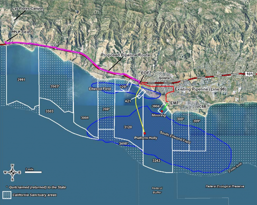
In 2012, Venoco’s (actually a wholly owned subsidiary of Venoco called The Ellwood Pipeline, Inc.) Line 96 Modification Project completed a new pipeline spur in Goleta to shunt processed crude oil from their Ellwood Onshore Facility into the existing Plains All American Coastal Pipeline west of Las Flores Canyon.

As with most of our local pipelines, this Line 96 spur was built to reduce impacts and risks associated with moving oil and/or gas from offshore to refinery sites.  This particular pipeline was installed to eliminate the need for continued operations at Venoco’s Ellwood Marine Terminal, particularly eliminating oil barge operations adjacent to designated Marine Protected Areas.