Posts

Fall 2015 Wrap Up!

IMG_0842 IMG_0840No, this is not CSUCI!!

Thanksgiving trip to snowy beautiful Oregon- apparently this early 1+ foot of snow was not the norm for the area… maybe early sign of impending El Niño??

Fitting that I should experience such extreme weather as I continue the quest to get the CSUCI weather station off the ground. As the Fall 2015 semester winds to a close we have made great progress, but there is still much work to be done. Early builds of the CI Weather website are in the works, and test subjects will be needed for opinion surveys very soon – stay posted…

I hope that everyone is feeling good about their respective semesters, and I know we are all excited to get into Spring, get our work done and make it happen. We have a great community at CI, and I am proud to be a part of it.

Cheers to all!!

Update

This week all I have done for my capstone is work on my introduction. I will not be back in the classroom until February, that makes me sad. Winter break is almost here but this is when I will get a lot of work done.

Capstone Intro Is ALL Done!

Here’s my abstract:

“For many of us, water simply flows from a faucet, and we think little about it beyond this point of contact. We have lost a sense of respect for the wild river, for the complex workings of a wetland, for the intricate web of life that water supports.” Sandra Postel from Last Oasis: Facing Water Scarcity. (1997). This paper and subsequent monitoring will try to begin to understand the complex workings of the wetland marsh systems located on Santa Rosa Island in the Channel Islands National Park. Furthermore, the purpose of the monitoring protocol will be to provide a more in depth understanding of the functions, structure, and ecological significance of this marsh system.

There are typically two, occasionally three coastal, apparently tidal marshes, which flow out of Old Ranch Canyon, Old Ranch House Canyon, and Quemada Canyon watersheds. These are ephemeral streams on a semi-arid Southern California Island that receives only 15 inches of rain a year (NOAA weather data 2015). Even though these watersheds are some of the larger streams on Santa Rosa, the lagoons do dry up, especially during this time of extreme drought. This vital signs monitoring project will perform water quality and temporal-seasonal change surveys on a long-term periodic scale. This protocol is in efforts to help the National Parks Service and other ecological surveyors better understand the history and the future of a semi-arid climate marsh and watershed system. The long-term monitoring program being implemented for the marsh systems on Santa Rosa Island must look at a number of parameters to determine the health of this ecosystem along with its potential productivity and ecosystem services. By deploying the salinity, temperature, and other water quality parameters, along with vegetation and aerial photo studies, we can get a significant snapshot of the changes and varying influences of the marshes.

 

Presented at RJ Frank Middle School

On Thursday December 10, 2015, Brandon and I presented an overview of our capstone to about 30 students at RJ Frank Middle School. We discussed where the Torrey pines are found, their population growth on Santa Rosa Island, causes of population decline, Geographic Information Science, and germination. At the end of this presentation, we had everyone plant their own seeds to grow at home. The students had a choice between peas, watermelon or rosemary to plant. The most popular seed was watermelon.


Torrey pine seeds

Relocation of Stickleback

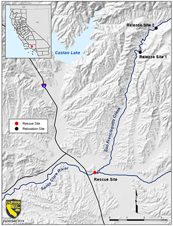
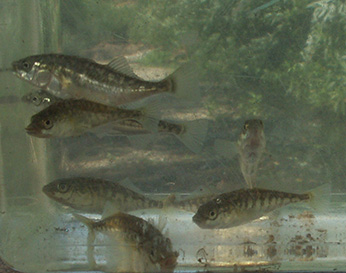
This is an interesting post made by the U.S. Fish and Wildlife Service about a relocation of unarmored threespine stickleback in June of 2015 where they moved a population from the Santa Clara River (where drought conditions were severe) to San Francisquito Creek. This was done to protect the highly endangered fish from extinction. From my observations it seems they are now extirpated from the rescue site.

https://www.wildlife.ca.gov/Conservation/Inland-Fisheries/Projects/Stickleback

Stickleback-Map multiple Fishes

photos taken from the USFWS link above


Getting Started

Just starting to sort of look at the best way to teach my high school kids about the environment. I never really realized how many different ways people can teach. It’s a little insane. It all just depends on what you are teaching, what kind best suits you and which one reaches the majority of the students. In a perfect world you would be able to reach all of the students with just one style but we don’t live in a perfect world, guess it looks like there will be two different kinds of teaching meshed into one.

Weekend December 4-5

This past weekend was very productive. Starting with Wednesday, I helped assist with the high school program “Be Wet”. The program uses college students within the STEM majors as mentors for high school student. I went to Channel Island to tell them about my capstone project. The opportunity allowed me to build experience presenting my research in a non-stressful environment. The presenting continued into Linda O’Hirok’s ESRM 100 Class where I recruited helpers with my data collection the coming weekend. The ESRM student received “service learning” hours while I gained leadership and presentation skills. Friday’s group of helps assisted me with profile surveying, sand collection, and GPS tracks. We were extremely productive and collected data at all five of my transects. Saturday was also highly productive. Previous capstone students studying the nourishment at Port Hueneme, have looked at biological factors and biological diversity on the beach. Saturday’s group assisted in “sandy beach protocol” where primarily clam guns and mesh screens were used to assess the health of beaches. Measurements of infauna, such as sand crabs, was collected. My personal observations saw few sand crabs present for the majority of the beach. The data collected will be eventually compared against last year’s data. Last week was very productive and allowed me to learn many new experiences. 20151123_135914 20151204_112511

SCURR Nov. 21st

This last weekend I attended The Southern California Conference for Undergraduate Research (SCCUR). It was my first time attending a conference and had a really good time. It was inspiring to listening to other undergraduate research and their presentations. My poster presentation was a success. I presented the research I collected over the summer with Project ACCESSO. Some of the results we found during that research was that the sand grain size impacted the heterogeneity (H’). When beaches had fine grained sand there was higher heterogeneity, and with larger gains of sand there was less heterogeneity of infauna. Along with my colleges, Aimee Newell and Jayla Fendi, we presented a poster of our work. The weekend was really fun and exciting.

20151121_15400120151121_131011

Nov. 9th New Data Collected

This week I expanded my research sites. I collected my normal data at Port Hueneme Beach and we also collected at Hollywood Beach. Hollywood Beach is just north of Channel Islands Harbor and Port of Hueneme. Sand from the Santa Clara River Mouth travels south and builds up against the jetty at Hollywood beach. This is the dredged sand used to nourish Port Hueneme Beach. We took survey profiles, sand, and shoreline tracks. This comparison should be interesting to compare against Port Hueneme beach erosion. My prediction is that we will see similar sand types on both of the beaches. We will also see similar rates of erosion from Port Hueneme and nourishment on Hollywood. This week I also started analyzing my profile data. We can already see some of the changes occurring on the beach.

tran1graph20151123_135925

Dead Week

This week has consisted of writing my introduction for my paper. Lots of studies are being read to help with information related to terrain analysis and vegetation mapping. Five other finals and work have me competing for time so this week has been a struggle.