Posts
Paper Editing
/in /by Jay WoolseyThis week finals are coming up and the intro to Capstone is due soon. We have been working with ArcGIS, background maps and how to display our data. we have also been utilizing images captured on SRI to give background info on the island and my research. My paper is also being reviewed by peers and professors. Two of four have returned and the paper is being edited later this week.
Point of Entry 3
/in /by Danielle Martinez
The final Point of Entry that I will be surveying is the airstrip. This image shows the hardscape (zone 1) and the 20 meter buffer zone around it (zone 2). I wanted to walk along it to see what types of vegetation there was and what the hardscape was like, but that would require advanced collaboration with the National Parks to ensure it is safe and no planes are around. This image is from the Invasive Plant Monitoring protocol from NPS.
Point of Entry 2
/in /by Danielle Martinez
For the second point of entry, which was the campsite, I decided to use a different method to catalog the hardscape. This time I decided to create GPS way points at every turn or bend around the perimeter as opposed to having the device continuously recording my steps. I found this method to be a lot slower given that I had to stop completely in order to record the way point and save it, as opposed to non-stop walking the perimeter. However, once I uploaded my results, it was clear that this method was much more accurate. There were no way points that seemed off and I came up with a very clean reference to use once I re-create this as a polygon in Arc-Map.
Point of Entry 1
/in /by Danielle Martinez
On my last trip out to Santa Rosa Island this semester, I decided to get a good lay of the land and outline the area of my sampling sites. The first one was the Port and Cultural Center area. I spent several hours just walking the perimeter around the area and in between all the fences to see what would match up with the National Parks guidelines on what defines the “hardscape,” which is “developed area (e.g. compacted earth, gravel, pavement, fencing) and the first 50 meters” of connecting dirt roads and trails.1 Keeping this in mind, I walked around the area several times, each time exploring something new to see what would fit this criteria. On my last go, I had a GPS device constantly running and I walked the exact perimeter in accordance with the guidelines and came up with a hardscape for my first point of entry. There were a few errors with the GPS device cutting out in signal with this method so there are points in which it appears that I cut through structures and fences, however I will re-create this in Arc-Map cleaner now that I have a good visual of the hardscape and how far 50 meters in on the trails.
1 Irvine, Irina C., et al. Invasive Plant Monitoring in the Mediterranean Coast Network: Santa Monica Mountains National Recreation Area and Channel Islands National Park. 2015. Print.
Research Paper Progress
/in /by Brice PritchardWith the completion of the schedule of my project and the overall outline for the semester progress has begun on the introduction for the paper. Some additional source need to be found in order to iron out some of the rough edges but progress is being made. I expect the paper to be finished sometime this week before Friday.
New Santa Rosa Updates
/in /by Brice PritchardSanta Rosa Island research has gone well and progress is being made though it is slow. Trips being spaced so far apart as well as class and work makes getting out to the island difficult. Over the past several trips somewhere in the range of 600 trees have been counted. Since this post I have been to the island 2 times. One time I was out and was only able to get to the research site for one day due to illness. The second time I was given a research assistant and was able to count about 230 trees. This is the map from that trip.

Downstream from Waste Water Treatment Plant
/in /by Holly GalbreathThese pictures were taken under the Iron Horse Trails bridge off of Magic Mountain Parkway. It is downstream from the picture in the last blog. There were larger pools of water here but I did not see any stickleback. This was a known location of unarmored stickleback in the U.S. Fish and Wildlife Review from 2009. The pictures shown below are of the stream and as I moved closer to the waste water expulsion area there was a strange orange growth in the water and some parts had oily bubbles on the surface as well.
About Me
/in /by Daniel TurekWelcome to my world! Here’s me with a very nice Hawaiian girl I met while on the Big Island…
Hey, that’s my wife!
But really, here’s my story:
Born on a chilly January day in Los Angeles County, I came into the world right in the middle of a city that is globally known for three things – “reality show” celebrities, miles of Baywatch-infused raked beaches (leave the wrack, people!), and some really bad, if not the worst at the time, air quality on earth.
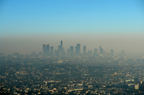
(Wait, there’s a city in there??)
Perhaps that more than anything led me to the realization that environmental damage is one of the worst aspects of modern society – and although major strides have been taken (thank you NEPA!), there is still much work to be done.
Enter: California State University, Channel Islands. From all the institutions of higher learning on earth, I found myself at CSUCI, majoring in ESRM, Environmental Science and Resource Management. And over the years I have studied at CI, I have learned so much that I kind of laugh when I think about how little I knew about the workings of the world before I started in ESRM. Every choice we make has consequences – but not all of the consequences have to necessarily be negative. Recycling is a choice; not creating the product in the first place is another choice. How we as a species weigh the myriad choices presented to us everyday will decide our collective future, and the future of all life on earth.
But I digress; this is about me, not the planet and all of its intricacies.
I was born in SoCal, but raised and introduced to things in the SF Bay Area. The Bay is a great place to grow up. Although most people today will tell you it’s full of nothing but tech entrepreneurs and indigent people, there is a culture there like no other.
All my experiences have led me to the present day – in many ways I see the future as a battle between the light side of the Force (natural living, free from pollution and environmental degradation), and the dark side (exploitation of all resources, poor air and water quality, and loss of species and diversity).
I know where I stand – I will always fight the dark side; now where’s my lightsaber??